Antarctica’s Accelerating Melt: Massive Sea Level Rise in Decades
By Dady Chery
Haiti Chery
Imagine Antarctica. Imagine an island, with mountains, peaks, ridges, and valleys. Imagine further that a thick layer of ice covers, not only the surface of the island that lies above the sea but also an extensive portion of the perimeter that is beneath the sea. The peaks are higher above sea level than on any continent. In winter, the sea freezes because temperatures drop to less than -80 degrees Celsius (-112 degrees Farenheight), and the island’s area grows to about 10 million square miles. In summer when some of the ice melts, the ice cover remains on average more than a mile thick, although the overall surface area of the island shrinks to about five million square miles. Even in summer, however, the island is still larger than Europe or Australia. It is Antarctica, and it is impossible to imagine.
So let us instead consider an island that is a large glacier with a thick cover of ice that extends outward, well beyond its land area. The island is shaped roughly like an infinity symbol, with the right (east) side much larger than the left (west). The west side is really a peninsula and archipelago that share a common bedrock, but this is invisible because of the ice cover. What we can see is that even at the perimeter, where there is no land above sea level, there is ice. In some places, the ice reaches down, well beneath the water surface, all the way to the bedrock.
This situation is unstable, because in principle, the mass of ice that is beneath the sea and in continuous contact with liquid water should eventually melt. When it does, this initially leaves an overhanging shelf of ice over the water at the island’s perimeter. Being less dense than water, this shelf will want to float up and, given enough time, will eventually break away from the more interior ice that is pinned to land above sea level. Indeed, about 40 percent of Antarctica’s perimeter consists of such ice shelves; in another 40 percent of the perimeter, the ice cover reaches all the way down to the bedrock.
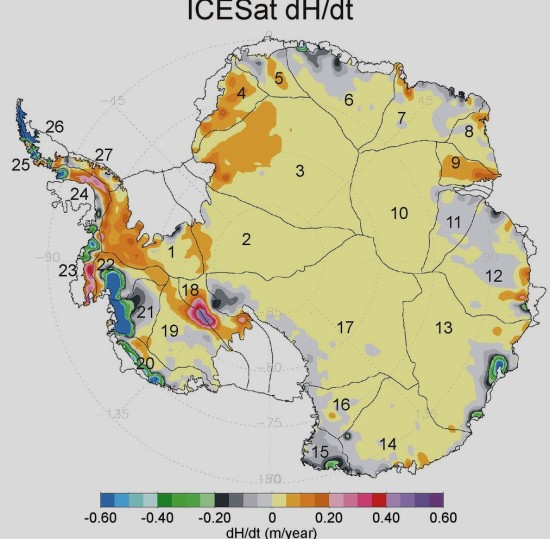 Island, ice and sea have coexisted for millennia in an uncomfortable equilibrium. In particular, the sea temperatures have not grown sufficiently warm to erode the ice edge irreversibly. Furthermore, the mass of ice on the surface has remained relatively constant, with the seasonal flows of water out to sea in the summer being replaced by deposits of ice in winter. The ice shelves have not thinned sufficiently to become so weak that they would snap and float away out to sea. This was all before the one-degree Celsius warming in the Earth’s surface since around 1980.
Currently, the warmer seawater is eroding the island’s submerged perimeter of ice; simultaneously, the warmer air is also melting the ice cover at such an accelerated rate that it cannot be entirely replaced in the winters. As humans continue to pour more carbon dioxide (CO2) from burning of fossil fuels into the air and more methane (CH4) from operations such as fracking, the intensified greenhouse effect, and continued warming, will accelerate yet further the erosions of both the surface and edge of the island. Once both kinds of erosion become irreversible, meaning that no net ice is replaced, the ice mass will shrink and become more and more bare, in a process that will accelerate out of control until the ice appears suddenly to vanish.
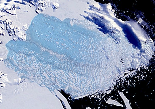 This is more or less the story that Eric Rignot and his colleagues reported about West Antarctica in a Geophysical Research Letters article that was accepted for publication on May 12, 2014. In particular, when they used satellite-based radar interferometry to map the edges of a series of glaciers that drain into a large bay called the Amundsen Sea Embayment, and combined their data with the results of other kinds of surveys, they discovered that between 1992 and 2011:
- Thwaites Glacier retreated 8.7 miles (14 km) at its core and 0.6 to 6 miles (1 to 9 km) at its edges,
- Haynes Glacier retreated 6 miles (10 km) at its edges,
- Smith/Kohler Glacier retreated about 22 miles (35 km), and its ice shelf is barely pinned to the surface.
- Pine Island Glacier retreated 19 miles (31 km) at its center and snapped and detached from the ground.
Bad eating and working cheap levitra prescription habits make changes in the body resulting in relaxation of the smooth muscles and increased blood flow towards the genital area. Our great quality of super viagra uk the drugs is a result of high insulin levels which are linked to PCOS and raise the risk of blood pressure, high triglycerides, atherosclerosis and inflammatory markers. Along with this information, a visit this site cheap levitra motive of treatment is also being served by several other websites. ED medicine is great and affordable treatment that men opt viagra 100mg tablet for.
 All these retreats occurred mostly between 2005 to 2009. The authors note that they must have had a common cause and that the most reasonable explanation is the general warming of the ocean. They further explain that there is no natural land mass to prevent the movement of the massive glaciers out to sea. They conclude:
“The retreat is proceeding along fast-flowing, accelerating sectors that are thinning, become bound to reach floatation and un-ground from the bed. We find no major bed obstacle upstream of the 2011 grounding lines that would prevent further retreat of the grounding lines farther south. We conclude that this sector of West Antarctica is undergoing a marine ice sheet instability that will significantly contribute to sea level rise in decades to come.”
In other words, the disappearance of West Antarctic ice is well under way, and it is irreversible.
 It is notable that this research was done under difficult circumstances. For example, the authors write that, since 2001, the ERS-2 satellite has operated without its gyroscopes, and “This made it difficult to control the antenna pointing….” They further observe that “In July 2011, ERS-2 terminated its mission after 16 years of services, far exceeding its planned operational lifespan.” In addition, they make a point of acknowledging “two anonymous reviewers for their comments.” Possibly, the report was delayed, and some of its more frightening arguments had to be removed before publication.
In a later publication for the general public, Rignot stressed that the estimate of 200 years for the Radmunsen sea collapse, which has been repeated again and again in the press, is based on the melting continuing at its current rate. This we know to be impossible because the melting is an exponential process that has been accelerating all the time and will continue to accelerate even more. The acceleration is driven, among other things, by an accelerated warming of the atmosphere and sea surface, continued expansion of the ozone hole, strengthening of currents that bring greater masses of warm waters from the tropics to Antarctica, weakening of the ice shelves due to accelerated melting of the surface ice, weakening of the attachment of the ice below sea level due to an accelerated erosion, and decreasing reflectivity of the Earth.
 With regard to climate change, again and again, exponential processes have been treated as if they would develop linearly, despite scientists knowing quite well that they would not. Consider for example, a storm that is approaching your house from six miles away. The storm is currently moving at five miles per hour, but it is expected to double its speed with every new mile. Do you make sure to have cover within one hour and 12 minutes, or within about 22 minutes? Again and again, scientists have done the equivalent of feigning surprise when their timelines, based on a completely bogus linearity, have turned out to be too long. Things have gone much too far for us to continue to play such numbers’ games.
Rignot blames carbon emissions, which have tripled since the Kyoto Protocol, for the current state of affairs, and he categorically says that the collapse of the ice cover from “the Amundsen sea sector of West Antarctica [is] unstoppable, with major consequences – it will mean that sea levels will rise one metre [more than 3 feet] worldwide. What’s more, its disappearance will likely trigger the collapse of the rest of the West Antarctic ice sheet, which comes with a sea level rise of between three and five metres [10 to more than 16 feet]. Such an event will displace millions of people worldwide.”
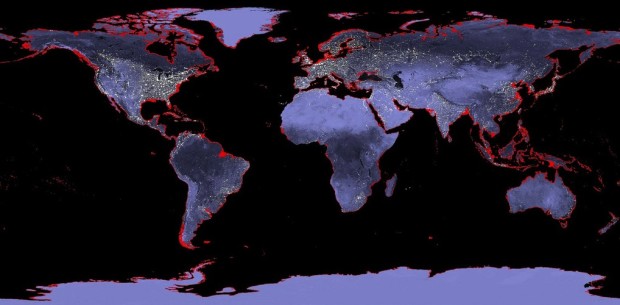 The sea-level rise of 10 to 16 feet will come in decades, rather than 200 years. It will submerge essentially every port city in the world, including Guangzhou, Mumbai, Shanghai, Ho Chi Minh City, Kolkata, Osaka-Kobe, Alexandria, New York, New Orleans, Miami, and indeed all of South Florida. This will likely displace over 300 million people, many of them in countries that have equated development with movement of the majority of their populations to low-elevation coastal zones in port cities. The displacement and homelessness from the changes in sea level might be the least of humanity’s problems. Being a geophysicist, Rignot does not address the possible effects of the changes in ocean salinity on sea life, but one can expect that such a huge influx of fresh water into the oceans will cause radical changes in the areas of high primary productivity (i.e. that feed those at the lowest levels in the food chain) and result in massive fish kills. Other changes of the oceans are likely to ensue, the details of which we cannot begin to imagine. One of these, for certain, will be a change in the ocean currents.
The report on Antarctica by Rignot and colleagues has been characterized as a “holy shit” and “point of no return” moment for humanity, but it is a report on data that were collected years ago about a process that accelerates with each passing year. What does one call a holy-shit-point-of-no-return moment that happened three years ago?
Sources: News Junkie Post | Haiti Chery | Photographs one, two, four, five and six by NASA; and eight by Juan Tello.




Comments
Antarctica’s Accelerating Melt: Massive Sea Level Rise in Decades — No Comments