No Time Left to Adapt to Melting Glaciers | Noroeste de Perú sin tiempo para adaptarse al deshielo glaciar
By Stephen Leahy
IPS | Tierramerica
English | Spanish
UXBRIDGE, Canada – The water supplied by the glaciers of the Cordillera Blanca, vital to a huge region of northwest Peru, is decreasing 20 years sooner than expected, according to a new study.
Water flows from the region’s melting glaciers have already peaked and are in decline, Michel Baraer, a glaciologist at Canada’s McGill University, told Tierramérica. This is happening 20 to 30 years earlier than forecasted.
“Our study reveals that the glaciers feeding the Río Santa watershed are now too small to maintain past water flows. There will be less water, as much as 30 percent less during the dry season,”
said Baraer, lead author of the study “Glacier Recession and Water Resources in Peru’s Cordillera Blanca”, published Dec. 22 in the Journal of Glaciology.
When glaciers begin to shrink in size, they generate
“a transitory increase in runoff as they lose mass,”
the study notes.
However, Baraer explained, the water flowing from a glacier eventually hits a plateau and from this point onwards there is a decrease in the discharge of melt water.
“The decline is permanent. There is no going back.”
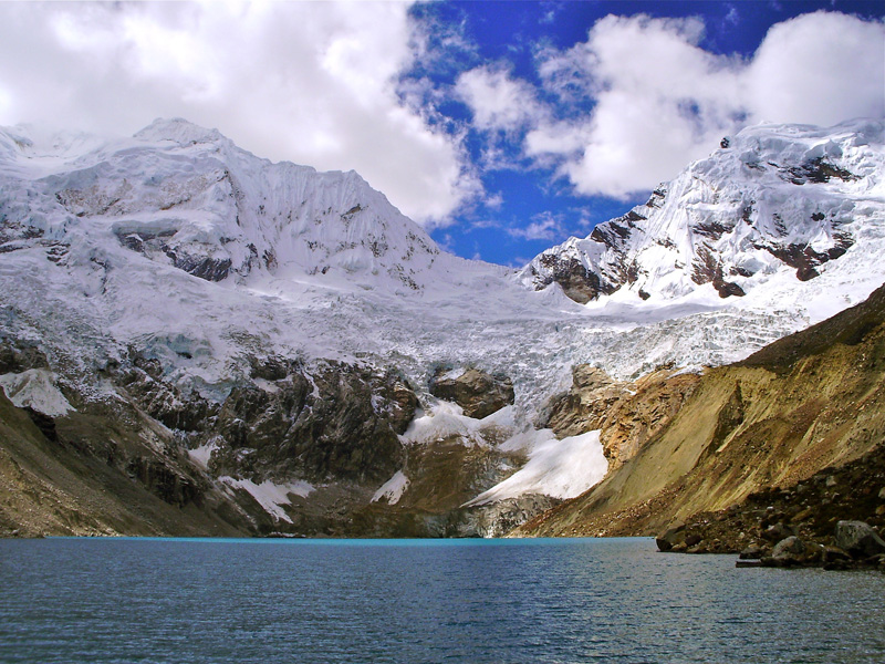
Melt water from glaciers of the Cordillera Blanca forms lagoons that feed rivers and streams (Credit: Michel Baraer).
Part of the South American Andes Mountain chain, the Cordillera Blanca is a series of snow-covered peaks running north to south, parallel to the Cordillera Negra, located further west. Between the two ranges lies the Callejón de Huaylas, through which the Río Santa runs, eventually emptying into the Pacific Ocean.
The tropical glaciers of the Andes Mountains are in rapid decline, losing 30 to 50 percent of their ice in the last 30 years, according to the French Institute for Research and Development (IRD).
Most of the decline has been since 1976, IRD reported, due to rising temperatures in the region as a result of climate change. In Bolivia, the Chacaltaya glacier disappeared in 2009.
Even in the colder regions of the Andes glaciers are in full retreat. Chile’s Centre for Scientific Studies reported this month that the Jorge Montt Glacier in the vast Patagonian Ice Fields receded one entire km in just one year. Historically glacial retreat is extremely slow: one or two km per 100 years.
Melting glaciers around the world present some of the strongest evidence that global climate change is underway, said Lonnie Thompson of Ohio State University, the world’s foremost glaciologist.
Thompson warns that without sharp reductions in the use of fossil fuels, the impacts of climate change could come faster and beyond what humanity can adapt to.
Warmer temperatures not only melt ice but also have major effects on snowfall.
As cool seasons become warmer and snow turns to rain, the amount and duration of snow packs decrease and the permanent snow line moves upslope, according to the Inter-American Institute for Global Change Research (IAI), an intergovernmental science organisation based in São José dos Campos, Brazil.
These changes have significant effects on the seasonality of stream flows, increasing winter flow rates while the availability of water during the summer declines when water in streams and rivers comes mainly from snow and ice melt.
In many High Andean tropical and subtropical valleys, spring and summer snow and glacier melt are critical for crops, livestock and human consumption. Several major Andean cities rely heavily on glacier and snow melt for their water supply, such as La Paz and Lima, with demand increasingly outstripping the supply, according to a 2010 IAI communiqué.
The Cordillera Blanca has the most glaciers of any tropical mountain range in the world. In the 1930s glaciers covered up to 850 sq km of the region and now they cover less than 600 sq km, reports Baraer and the eight other study authors from McGill University, Ohio State University, the University of California, the IRD and the glaciology unit of the Peruvian National Water Authority.
Most of the melt water from these glaciers drains into the Río Santa watershed. The researchers compared detailed water flow measurements from the 1950s to water flows in recent years, and determined that of the nine sub-watersheds of the Río Santa, seven have passed their peak water flow and are in decline, and almost all of the decline is during the dry summer months.
Changes in precipitation and the effects of La Niña and El Niño were also assessed and were not responsible for the declines, Baraer said.
Until now it was widely believed that such declines would take place 20 to 30 years from now, allowing time to adapt to a future with less water.
“Those years don’t exist,” said Baraer.
The region is extremely dry, and the Callejón de Huaylas and especially the agriculturally important province of Carhuaz are completely dependent on water from the Río Santa to irrigate the extensive fruit and vegetable fields, he said.
The Río Santa is also the main source of drinking water for cities in the area, as is the case of many rivers in the Andean region. For instance, Lima, the world’s second largest desert city after Cairo, depends on water from the Río Rímac watershed, also in the Andes.
“The northern Andes (in Peru) are close to being a desert. It is the water from the glaciers that has allowed people to survive here,” Baraer said.
Last summer, researchers took measurements of the Río Santa’s water volume from the estuary where it reaches the Pacific all the way up to its sources in the Andes. They found that less than 20 percent of the water reaches the ocean now.
“Eighty percent of the water from the Santa is already being used,” he said.
Projections into the future reveal that in the coming decades some Río Santa sub-watersheds will have 30 percent less water – a serious challenge to the entire region when 80 percent of current volumes are already being used, Baraer stressed.
“This water decline is guaranteed. The only question is how much and how quickly,”
he said. There is already so much carbon in the atmosphere from the burning of fossil fuels that it is
“already too late for most of the glaciers in the Andes,” he concluded.
Sources: IPS | Tierramerica | The writer is an IPS correspondent. This story was originally published by Latin American newspapers that are part of the Tierramérica network.
Por Stephen Leahy
IPS
español | inglés
UXBRIDGE, Canadá – El agua que suministran los glaciares de la cordillera Blanca, vital para una extensa región del noroeste de Perú, está menguando 20 años antes de lo esperado, afirma una nueva investigación.
El flujo de agua del derretimiento de los glaciares de la zona ya llegó a su cota máxima y ahora está en declive, dijo a Tierramérica el glaciólogo Michel Baraer, de la canadiense McGill University. El fenómeno se registra entre 20 y 30 años antes de lo que se preveía.
“Nuestro estudio revela que los glaciares que alimentan la cuenca del río Santa ya son demasiado pequeños para mantener los anteriores flujos hídricos. En la temporada seca habrá hasta 30 por ciento menos agua”,
señaló Baraer, autor principal del estudio “Glacier Recession and Water Resources in Peru’s Cordillera Blanca” (Retroceso de glaciares y recursos hídricos en la cordillera Blanca de Perú), publicado el 22 de este mes en la revista británica Journal of Glaciology.
Cuando el tamaño de los glaciares empieza a reducirse, se genera
“un aumento transitorio de la escorrentía a medida que pierden masa”, afirma la investigación.

El agua del deshielo glaciar de la cordillera Blanca forma lagunas que a su vez alimentan ríos y arroyos (Crédito: Michel Baraer).
“El agua del derretimiento termina llegando a una meseta y a partir de allí se registra una reducción de la descarga procedente del deshielo”, explicó Baraer.
“La disminución es permanente. No hay vuelta atrás”.
Parte de la gran cadena montañosa americana de los Andes, la cordillera Blanca es una sucesión de picos nevados, emplazada de norte a sur y paralela a la cordillera Negra, situada más al oeste. Entre las dos forman el Callejón de Huaylas, por donde discurre el río Santa, cuyo último tramo, en dirección sudoeste, desemboca en el océano Pacífico.
Los glaciares tropicales andinos están en rápido declive. En los últimos 30 años perdieron entre 30 y 50 por ciento de sus hielos, según el francés Institut de Recherche pour le Développement (IRD, Instituto de Investigación para el Desarrollo).
Buena parte de esa pérdida se registra desde 1976, según el IRD, y es atribuible al aumento de las temperaturas a consecuencia del cambio climático. En Bolivia, el glaciar Chacaltaya desapareció en 2009.
Incluso las zonas más frías de los glaciares andinos están en retroceso. El Centro de Estudios Científicos de Chile informó este mes que el glaciar Jorge Montt, en el vasto Campo de Hielo Sur, se replegó un kilómetro en apenas un año. Según el registro histórico, los glaciares se reducen muy lentamente, a razón de uno o dos kilómetros por siglo.
El deshielo de las masas heladas continentales en distintas partes del mundo es una de las evidencias más firmes de que el cambio climático está en marcha, ha dicho el distinguido glaciólogo Lonnie Thompson, de la Ohio State University.
Thompson advierte que, de no limitarse drásticamente el uso de combustibles fósiles, los impactos pueden llegar más rápidamente e ir más allá de las posibilidades de adaptación de la especie humana.
Las temperaturas más cálidas no solo derriten el hielo, sino que tienen importantes efectos en las nevadas.
A medida que se calientan las estaciones frías y la nieve se vuelve lluvia, el tamaño y extensión de la capa nevada se reduce y el límite de las nieves eternas se halla cada vez más alto montaña arriba, según el Instituto Interamericano para la Investigación del Cambio Global (IAI), con sede en São José dos Campos, Brasil.
Estos cambios tienen efectos notorios en la estacionalidad de la escorrentía, cuando esta procede principalmente del derretimiento de nieves y hielos, acrecentando las corrientes en invierno, mientras en verano los ríos y arroyos tienen menos agua.
En muchos valles de los Andes tropicales y subtropicales, el derretimiento de glaciares en primavera y verano es crucial para los cultivos, el ganado y el consumo humano. Varias ciudades importantes dependen de esas aguas, como La Paz y Lima, cuya demanda supera cada vez más el suministro, según un comunicado divulgado en 2010 por el IAI.
La peruana cordillera Blanca tiene la mayor cantidad de glaciares de todas las cadenas montañosas tropicales del mundo. En la década de 1930, esos hielos cubrían hasta 850 kilómetros cuadrados, y a fines del siglo XX ocupaban una superficie inferior a los 600 kilómetros cuadrados, señalan Baraer y otros ocho investigadores de The Ohio State University, University of California, el IRD y la Unidad de Glaciología y Recursos Hídricos de la Autoridad Nacional del Agua de Perú.
La mayor parte de las aguas del deshielo se vierte en la cuenca del río Santa. Los investigadores compararon mediciones del flujo hídrico tomadas desde los años 50 a los 90 y concluyeron que de las nueve subcuencas del Santa estudiadas, siete
“ya pasaron su punto de inflexión y ahora exhiben una decreciente descarga hídrica en la estación seca”.
También evaluaron los cambios en las precipitaciones y los efectos de los fenómenos climático-atmosféricos de La Niña y El Niño, y concluyeron que estos no son responsables de la reducción de la escorrentía, dijo Baraer.
Hasta ahora se creía que esta disminución se registraría en 20 o 30 años, dando tiempo para adaptarse a un futuro con menos agua. Pero
“esos años no existen”, insistió Baraer.
La zona es extremadamente seca, y el Callejón de Huaylas y la provincia agrícola de Carhuaz dependen completamente de la cuenca del Santa para irrigar sus extensos huertos de frutas y verduras, dijo.
El Santa es también la principal fuente de agua potable de las ciudades de la zona, como ocurre con buena parte de los ríos andinos. Es el caso de Lima, la segunda ciudad desértica más poblada del mundo después de El Cairo, que depende de la cuenca andina del río Rímac.
“Los Andes del norte (de Perú) están cerca de convertirse en un desierto. Fue el agua de los glaciares lo que permitió que la población sobreviviera allí”, dijo Baraer.
En el pasado verano austral, los investigadores midieron el volumen hídrico del Santa desde su desembocadura en un estuario del Pacífico hasta sus nacientes en las alturas andinas. Concluyeron que menos de 20 por ciento llega actualmente al océano.
“Ochenta por ciento del agua del Santa ya se está usando”, explicó Baraer.
Algunas proyecciones sostienen que en las próximas décadas varias subcuencas del Santa tendrán 30 por ciento menos agua, lo que entraña un serio desafío para toda la zona.
“La disminución del agua está garantizada; la única pregunta es cuánta se perderá y a qué velocidad”,
señaló Baraer. En la atmósfera hay tanto dióxido de carbono por la quema de combustibles fósiles que
“ya es demasiado tarde para la mayoría de los glaciares andinos”, concluyó.
Fuentes: IPS | Tierramerica | El autor es corresponsal de IPS. Este artículo fue publicado originalmente el 24 de diciembre por la red latinoamericana de diarios de Tierramérica.




Comments
No Time Left to Adapt to Melting Glaciers | Noroeste de Perú sin tiempo para adaptarse al deshielo glaciar — No Comments